All zones now open to residents; Crews remain vigilant in detecting hot spots
by Mescalero Apache Tribe | June 29, 2024 9:31 am
Daily Update, Saturday, June 29, 2024
Mescalero Apache Tribe Emergency Operations Center: 575-464-9214 (8am-12am)
Village of Ruidoso and Lincoln County Emergency Operations Center: 575-258-6900 (7am-10pm)
Fire Information Phone:575-323-8378 or 575-323-8258 (8am-8pm)
Media Information Phone: 575-323-8053 (8am-8pm)
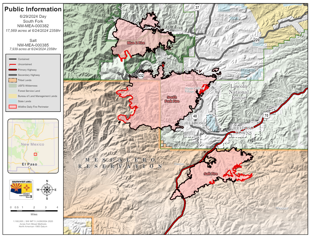
Email: 2024.southfork@firenet.govAcres: South Fork – 17,569; Salt – 7,939
Start Date: June 17, 2024
Location: South Fork – Ruidoso Area, Salt – 7 mile west of Mescalero, NM
Personnel: 780
Containment: South Fork – 77%; Salt – 77%
Fuels: mixed conifer, grass, pine/juniper
Resources: The South Fork and Salt fires are currently staffed with 18 crews, 4 helicopters, 31 engines,
4 bulldozers, and 10 water tenders.
Highlights: As of today, Saturday June 29, the South Fork and Salt fires burned roughly 25,000 acres across private, public, and tribal lands.
Mescalero Apache Reservation evacuation and donation sites: Evacuation sites on the Mescalero Apache Reservation are now closed. Donations will be taken and distributed to tribal members in need at the Inn of the Mountain Gods’ convention center from 9 AM – 4 PM daily. FEMA is located outside the Mescalero Community Center from 8 AM – 6:30 PM (until further notice). They are assisting the public with general government assistance (unemployment, EBT, etc.).
Village of Ruidoso reentry: All No Entry/Exclusion zones are now open. There are still firefighters, firefighting equipment, utility company workers and vehicles travelling through the area. Their work is critical to restore utilities and services, and conditions in the exclusion zones pose a safety risk to the emergency personnel as well as the public. Please be patient and allow them to complete their work. Contact the Village of Ruidoso and Lincoln County Emergency Operations Centers for more information.
Fire Activity: Friday’s clear skies, warmer temperatures, and decreased humidity created an environment favorable for the remaining isolated heat sources to dry out and increase combustion rates, making them easier to detect and extinguish. Additionally, thanks to infrared detection, ten remaining hot spots were identified and are a primary focus for firefighters this weekend. Crews will also conduct suppression repair, including chipping operations near Villa Madonna and repairing dozer lines where needed.
Weather: The South Fork and Salt fires experienced a brief drying trend as scattered showers moved away from the area Thursday through Friday. Saturday brings with it warmer temperatures and increased potential for scattered afternoon rains.
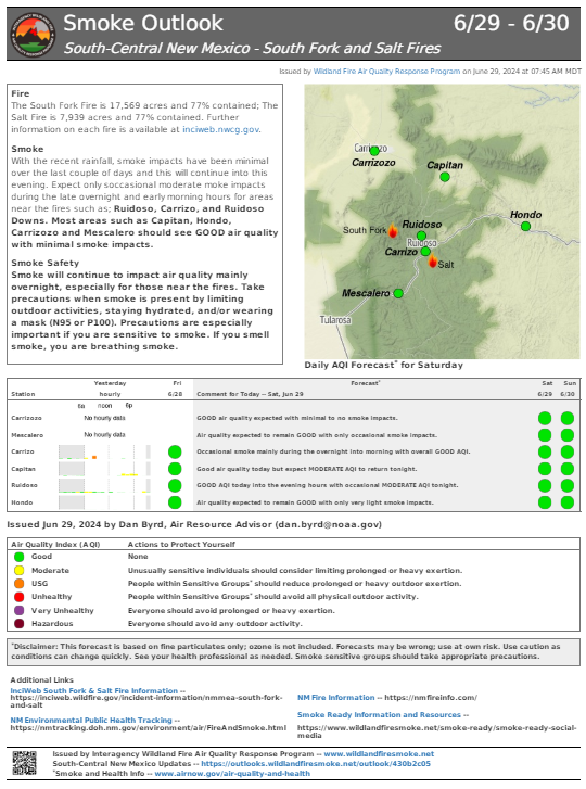
Smoke: Smoke will continue to have the biggest impact during the late overnight and morning hours for areas near the fires. Additional details are available at https://outlooks.wildlandfiresmoke.net/outlook/430b2c05[1].
Closures: A South Fork Fire Emergency Closure Order was issued on June 20, 2024, for national forest lands within the Smokey Bear Ranger District. The identified areas, and roads and trails therein, are closed to public access to allow firefighting personnel to work and through the fire area safely. More information is available at www.fs.usda.gov/alerts/lincoln/alerts-notices/?aid=88199[2]. The Mescalero Apache Tribe issued a Class V/Stage II – Extreme Fire Restriction Notice on June 28, 2024. More information is available at https://mescaleroapachetribe.com[3]. A Temporary Flight Restriction (TFR) is in place over the fire area. Public/commercial drone flights are also prohibited within this area. If you fly, we may have to ground our air resources. Visit https://tfr.faa.gov/tfr2/list.html[4] for more information.
More information:
Inciweb: https://inciweb.wildfire.gov/incident-information/nmmea-south-fork-and-salt
Facebook: https://www.facebook.com/SWIMT5[5]
Smoke Outlook: https://outlooks.wildlandfiresmoke.net/outlook/430b2c05[1]
Lincoln County Government: www.lincolncountynm.gov[6]
Mescalero Apache Tribe: https://mescaleroapachetribe.com[3]
Village of Ruidoso: www.ruidoso-nm.gov/south-fork-fire[7]
- https://outlooks.wildlandfiresmoke.net/outlook/430b2c05: https://outlooks.wildlandfiresmoke.net/outlook/430b2c05
- www.fs.usda.gov/alerts/lincoln/alerts-notices/?aid=88199: http://www.fs.usda.gov/alerts/lincoln/alerts-notices/?aid=88199
- https://mescaleroapachetribe.com: https://mescaleroapachetribe.com/
- https://tfr.faa.gov/tfr2/list.html: https://tfr.faa.gov/tfr2/list.html
- https://www.facebook.com/SWIMT5: https://www.facebook.com/SWIMT5
- www.lincolncountynm.gov: http://www.lincolncountynm.gov/
- www.ruidoso-nm.gov/south-fork-fire: http://www.ruidoso-nm.gov/south-fork-fire
- Download: https://mescaleroapachetribe.com/wp-content/uploads/pio_8x11_land_20240628_2018_SouthFork_NMMEA000382_0629day.pdf
- Download: https://mescaleroapachetribe.com/wp-content/uploads/430b2c05_20240629134620outlook.pdf
- Download: https://mescaleroapachetribe.com/wp-content/uploads/MediaRelDalyUpdate_20240629_000382.pdf
Source URL: https://mescaleroapachetribe.com/21310/all-zones-now-open-to-residents-crews-remain-vigilant-in-detecting-hot-spots/